Schneider Electric Marathon de Paris 2026: access, transport and areas to avoid on April 12
The Schneider Electric Marathon de Paris will take place this Sunday, April 12, 2026. This major sporting event brings together tens of thousands of runners every year and attracts very large crowds along the route. On this occasion, several areas of the capital will be particularly busy.
👉 Here is everything you need to know to get to the event and plan your travel in the area on the big day.
Schneider Electric Paris Marathon 2026: date and times
With its 42.195 km, the Paris Marathon is one of the largest marathons in the world in terms of number of participants. Organized by Amaury Sport Organisation, the race offers a route that passes through several iconic sites in the capital.
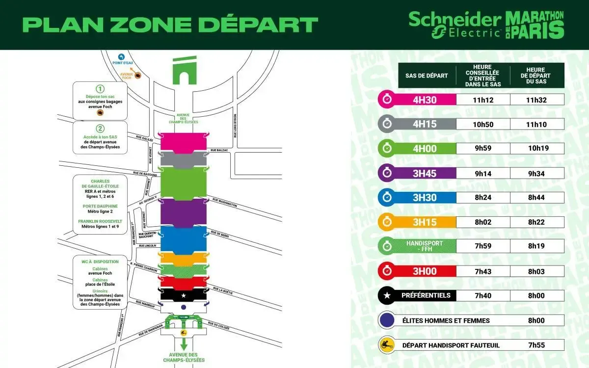
The start will take place on Avenue des Champs-Élysées, while the finish will be on Avenue Foch, after a course notably passing along the Seine riverbanks, Place de la Bastille, and the Bois de Vincennes and Bois de Boulogne.
- Date: Sunday, April 12, 2026
- Starts: staggered, from around 08:00
- Finishes: staggered from 10:00 until mid-afternoon around 16:30
- Attendance: around 55,000 runners, several hundred thousand spectators along the route (especially in iconic areas), and strong international participation
- High-traffic areas: Champs-Élysées and Concorde sectors (start area), Bastille, Seine riverbanks, Bois de Vincennes, Bois de Boulogne, and Avenue Foch (finish area)

How to get to the start of the Paris Marathon
Due to the many road closures within Paris city limits, the most reliable means of transport are public transit, cycling, and walking.
Getting there by public transport
| Line | Station |
|---|---|
    | Charles de Gaulle-Étoile |
| Porte Dauphine |
 | Franklin Roosevelt |
Tip: search for a route with the Bonjour RATP app: the best routes will be suggested while taking current or upcoming disruptions into account.
By bike
A supervised bike parking area, available by reservation, will be located at the intersection of Avenue Foch and Avenue de la Grande Armée near Place de l'Étoile. Vélib' stations are available near the start and finish.
Good to know: the Bonjour RATP app lets you find and rent a Vélib, Lime, Voi, or Dott in just a few clicks, and use pedestrian GPS to easily find your way. To learn more, click here.
How to get to the finish of the Paris Marathon?
You can reach the finish line by using public transport to the following stations:
| Line | Station |
|---|---|
| Charles de Gaulle-Étoile |
| Porte Dauphine |
| Franklin Roosevelt |
💡 Between 06:30 and 08:30 and between 10:30 and 15:30, the main stations and their entrances may experience slowdowns, temporary access controls, and high passenger volumes. If you are accompanying a runner, we recommend using a station slightly farther away and finishing on foot.
Traffic and areas to avoid
The 2026 route passes through very busy central areas, and the impacts are numerous: streets closed early in the morning, major bus diversions, difficult car traffic in central Paris, and traffic redirected to peripheral routes.
✔️ Recommended if you need to get around Paris for reasons unrelated to the event:
- Plan your schedule ahead
- Check real-time traffic conditions using the Bonjour RATP app
- Use public transport or a bike rather than a car
- Avoid central Paris if possible, especially the Champs-Élysées and Concorde areas (start zone), Bastille, the Seine riverbanks, the Bois de Vincennes, the Bois de Boulogne, and Avenue Foch (finish zone)
- Before leaving, use the Bonjour RATP app to check real-time traffic conditions and search for optimized routes